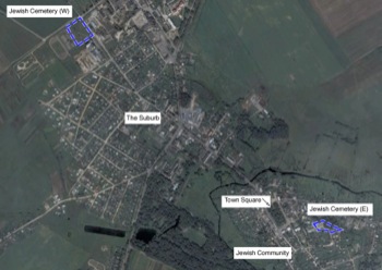
Our starting point is an interwar map of the town:
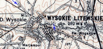 |
The Jewish Cemeteries (blue arrows)
A section of an inter-war Wojskowy Instytut Geograficzny
(WIG) 100K scale map, courtesy of mapywig.org |
(Click on map for larger view.) Two bounded areas containing symbols resembling the letter T indicates Jewish cemeteries. The one to the west was clearly outside the town limits, beyond the predominately Polish Suburb. The one to the east was at the edge of the traditional Jewish community, on a plot of land adjacent to the Roman Catholic (Provoslav) Church. The mapmaker clearly intended to convey the impression that the larger of the two was the one to the west.
The town can be viewed in modern aerial images, courtesy of Google Earth:
The Western Jewish Cemetery
The following photo is said to be a view of the western Jewish cemetery:
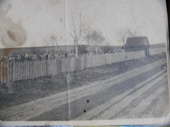 |
The Western Jewish Cemetery in Wysokie Litewskie.
courtesy of G. Musevich of Kamenets, Belarus |
At some point, the story is told, the only Jewish resident of Wysokie Litewskie in "The Suburb" (west of the Pulva River) was the caretaker of the Jewish cemetery there. The small house visible in the photo above is consistent with a caretaker living there.
This site is today adjacent to a college campus:
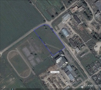 |
The site of the western Jewish Cemetery
courtesy of Google Earth |
There is still farmland to the northwest of the site today.
The Eastern Jewish Cemetery
The Jewish cemetery site to the east is adjacent to the town's long-existing Russian Orthodox (Provoslav) Church:
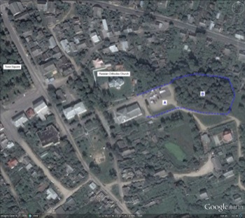 |
The site of the eastern Jewish Cemetery
courtesy of Google Earth |
The pre-war extent of this site is unknown. The WIG map above implies that it extended from the east side of the Russian Orthodox Church all the way to the east-west road that lies just to the north. Contemporary locals seem to agree.
Among descendents the story is heard that the Wysokie Jewish Cemetery is “paved-over”. The actual bounds of the cemetery are unknown; it is possible that the portion closest to the Russian Orthodox Church (marked “A”) is paved now. That area serves as a parking lot, on which a small flea-market is frequently found. The further portion (“B”) is covered with tall trees:
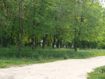 |
The site of the Eastern Jewish Cemetery
2007 photo by the webmaster |
The following old photos, unknown date, were provided by the descendant of a Wysokie family that lived adjacent to the
Eastern Jewish Cemetery:
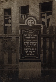 |
A Jewish Gravestone, Eastern Jewish Cemetery (1)
Courtesy of Ione Schatzman |
Translation, courtesy of Hannah Kadmon:
Honorable and righteous died at the prime of life
4th of November 1918
Yitzkhak Khayat son of R’ Betzalel
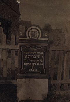 |
Jewish Gravestone, Eastern Jewish Cemetery (2)
Courtesy of Ione Schatzman |
Translation, courtesy of Hannah Kadmon:
Old dear and modest
Khaya Breina
daughter of R’ Yekutiel
Died 23rd of April 1919
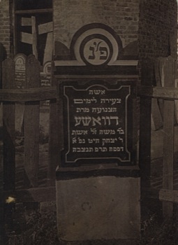 |
Jewish Gravestone, Eastern Jewish Cemetery (3)
Courtesy of Ione Schatzman |
Translation, courtesy of Hannah Kadmon:
A young modest woman
Dvoshe
daughter of R’ Moshe, wife of R’ Yitzkhak Khayat
Died 3rd of April 1920
| Editor's Notes: The T symbol on WIG maps indicates non-Christian cemeteries, so one or both of these could be Muslim. However there is no known record of a Muslim community here, and it seems to be common knowledge in modern Vysokoye that these are Jewish cemeteries. The actual designations used by the Jewish inhabitants to refer to these cemeteries are unknown; the descriptors Western and Eastern are used here for convenient reference only. Adjacent to: in the region, it is not exceptional that Jewish and Christian sites are intermixed. WIG map implies: experience shows fine-detail interpretation of WIG maps is is very difficult. Note that the only known story of a Wysokie Jewish cemetery is clearly about the eastern site, perhaps indicating that it is the newer of the two. |

